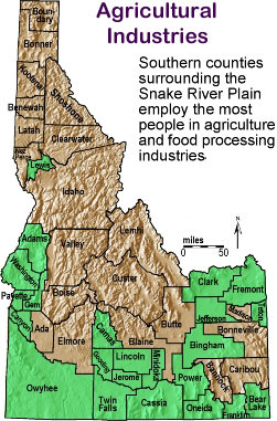
Labels:text | map | diagram | atlas OCR: Boun Agricultural dary Industries Bonner Southern counties Kootena surrounding the Shoshone Snake River Plain Benewah employ the most people in agriculture Latah Clearwater and food processing industries Low 'Idaho Adams valley miles 50 Washingtoni Custer Clark Fremont Boise Canyon Ada Cuma Butte Bonnevi Elmore Blaine Bingham Minidoks Lincoln Bannoci Caribou Jerome Power Owyhee Twin Cassia Bear Oneida t Lake